Natures Of Beauty Headline Animator

Showing posts with label Earthquake. Show all posts

9/23/12

Thunder And Lighting Description Protection And Images Collection

Description Thunder And Lighting:

 Thunder Lightning is a massive electrostatic discharge caused by unbalanced electric charge in the atmosphere.   Lightning can be either inside clouds , cloud to cloud or cloud to ground  and is accompanied by the loud sound of thunder. Because the speed of sound in air is so much slower than the speed of light. Thunder often lasts several seconds because the sounds from different parts of the lightning strike arrive at different times.

A typical cloud to ground thunder lightning strike is often over 5-6 km. long  but may be many kilometers longer. Lightning is usually associated with and produced by cumulonimbus clouds which may reach up to 15 km high and often have a base 5-6 km. above the ground.

The fear of thunder lightning is called astraphobia because of the severe danger of a close lightning strike this fear may be appropriate. The study or science of lightning is called fulminology  and someone who studies lightning is referred to as a fulminologist.

Each major stroke of a  thunder lightning strike is usually about 150 ft. long and lasts about 1 to 2 microseconds with a pause of about 50 microseconds as more charge is accumulated before resuming another stroke in a slightly or significantly different direction.

Protection:
  • Keep a weather radio during  thunder  lightning   season, especially when participating in outdoor activities.
  • Don't plan outdoor activities when   lightning   are predicted. 
  • Be aware of the general weather patterns in own area and plan smart. For example, an evening outdoor wedding in June in Minnesota had better have an indoor back-up plan  it would be much better to plan it for noon.
  • When camping, set up camp in or by a low grove of trees, preferably close to the floor of a valley. Stay off hilltops and avoid wide open fields . 
  • Stay off water and away from water when   lightning  approach.If you are outdoors when a storm approaches, the best thing to do is get indoors.
  • Roll up all the windows, close the doors, and do not touch anything metal. Do not use the radio or any other electronic devices until the storm  lightning   is well past.
Images:
Thunder Lighting Picture
 Lightning Image

Thunder Lighting Picture
 Lightning Image

Thunder Lighting Image
 Lightning Image

Thunder Lighting Picture
 Lightning Image

Thunder Lighting Wallpaper
 Lightning Image

Thunder Lighting Picture
 Lightning Image

Thunder Lighting Picture
 Lightning Image

Thunder Lighting Image
 Lightning Image

Thunder Lighting Image
 Lightning Image

8/22/12

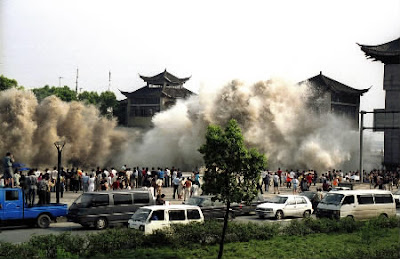
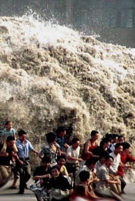
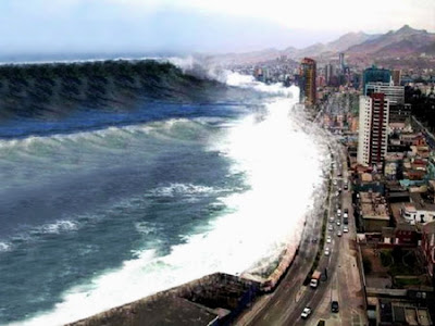
Tsunami A Natural Undersea Earthquake Facts And Images Collection

Introduction Of Tsunami:

A tsunami is a series of huge waves that can cause great devastation and loss of life when they strike a coast.
Tsunamis are caused by an underwater earthquake, a volcanic eruption, an sub-marine rockslide, or, more rarely, by an asteroid or meteoroid crashing into in the water from space. Most tsunamis are caused by underwater earthquakes, but not all underwater earthquakes cause tsunamis - an earthquake has to be over about magnitude 6.75 on the Richter scale for it to cause a tsunami. About 90 percent of all tsunamis occur in the Pacific Ocean.

The word tsunami comes from the Japanese word meaning "harbor wave." Tsunamis are sometimes incorrectly called "tidal waves" -- tsunamis are not caused by the tides (tides are caused by the gravitational force of the moon on the sea). Regular waves are caused by the wind.

Facts Of Tsunami:
  • A tsunami is a series of ocean waves that sends surges of water. Sometimes reaching heights of over 100 feet.
  • These awe-inspiring waves are typically caused by large undersea earthquakes at tectonic plate boundaries. When the ocean floor at a plate boundary rises or falls suddenly it displaces the water above it and launches the rolling waves that will become a tsunami.
  • Tsunamis may also be caused by underwater landslides or volcanic eruptions. .
  • Tsunamis race across the sea at up to 500 miles an hour about as fast as a jet airplane. At that pace they can cross the entire expanse of the Pacific Ocean in less than a day. And their long wavelengths mean they lose very little energy along the way.
  • In deep ocean, tsunami waves may appear only a foot or so high. But as they approach shoreline and enter shallower water they slow down and begin to grow in energy and height.
  • Some tsunamis do not appear on shore as massive breaking waves but instead resemble a quickly surging tide that inundates coastal areas.
  • The best defense against any tsunami is early warning that allows people to seek higher ground. The Pacific Tsunami Warning System, a coalition of 26 nations headquartered in Hawaii, maintains a web of seismic equipment and water level gauges to identify tsunamis at sea. Similar systems are proposed to protect coastal areas worldwide.
Images:

Tsunami Picture
Tsunami Image

Tsunami Image
Tsunami Picture

Tsunami Wallpaper
Tsunami Image

Tsunami Wallpaper
Tsunami Image

Tsunami Photo
Tsunami Image

Tsunami Picture
Tsunami Image

Tsunami Picture
The Huge Waves Of Tsunami

Tornado Introduction Cause Safety Precaution During And After Tornado And Images Collection

Introduction Of Tornadoes:

Tornadoes are nature’s most violent storms. Spawned from powerful thunderstorms. A tornado appears as a rotating funnel shaped cloud that extends from a thunderstorm to the ground with whirling winds that can reach 300 miles per hour. Damage paths can be in excess of one mile wide and 50 miles long. Every state is at some risk from this hazard.  Before a tornado hits the wind may die down and the air may become very still. A cloud of debris can mark the location of a tornado even if a funnel is not visible. Tornadoes generally occur near the trailing edge of a thunderstorm. It is not uncommon to see clear sunlit skies behind a tornado.

Cause Of Tornadoes:
  • When the ground grows warmer in spring and aloft is cold warm air near the surface rises.As it cools the water vapor it carries condenses forming clouds and thunderstorms.
  • Wind near the surface blow in one direction while winds aloft blow in another.
  • Rising warm air creates an updraft pulling the rotating air upright.Now the thunderstorm forms a rotating vortex on mesocyclone but only a few mesocyclones spawn tornadoes.Mesocyclone can be five miles across.
Safety Precautions  During a Tornadoes :
  • Go to a pre-designated shelter area such as a safe  room  or the lowest building level. 
  • If there is no basement, go to the center of an interior room on the lowest level  away from corners, windows, doors, and outside walls.
  • Do not open windows.
  •  If you are in vehicle immediately get into a vehicle, buckle your seat belt and try to drive to the closest sturdy shelter.
  • Put your head down below the windows cover your head with your hands and a blanket, coat or other cushion if possible.
  • If you can safely get noticeably lower than the level of the roadway, leave your car and lie in that area, covering your head with your hands.
  • Do not get under an overpass or bridge. You are safer in a low flat location.
  • Never try to outrun a tornado in urban or congested areas in a car or truck. Instead, leave the vehicle immediately for safe shelter.
  • Watch out for flying debris. Flying debris from tornadoes causes most fatalities and injuries.

Safety Precautions After Tornadoes:
  • Continue to monitor your battery-powered radio or television for emergency information.
  • Be careful when entering any structure that has been damaged.
  • Wear sturdy shoes or boots, long sleeves and gloves when handling or walking on or near debris.
  • Be aware of hazards from exposed nails and broken glass.
  • Do not touch downed power lines or objects in contact with downed lines. Report electrical hazards to the police and the utility company.
  • Seek prompt medical attention if you suspect CO poisoning and are feeling dizzy, light-headed or nauseated.
  • Hang up displaced telephone receivers that may have been knocked off by the tornado but stay off the telephone except to report an emergency.
  • Cooperate fully with public safety officials.
  • Respond to requests for volunteer assistance by police, fire fighters, emergency management and relief organizations, but do not go into damaged areas unless assistance has been requested. Your presence could hamper relief efforts and you could endanger yourself.

Images: 

Tornado  Picture
Tornado Image

Tornado Picture
Tornado Image

Tornado  Photo
Tornado Image

Tornado Wallpaper
Tornado Picture

Tornado Image
Tornado Picture

Tornado Picture
Tornado Image

8/10/12

Desert Introduction Classification And Images Collection

Introduction:

Dry areas created by global circulation patterns contain most of the deserts on the Earth. The deserts of world are not restricted by latitude, longitude, or elevation. They occur from areas close to the poles down to areas near the Equator. The People's Republic of China has both the highest desert, the Qaidam Depression that is 2,600 meters above sea level, and one of the lowest deserts, the Turpan Depression that is 150 meters below sea level. Deserts are not confined to Earth. The atmospheric circulation patterns of other terrestrial planets with gaseous envelopes also depend on the rotation of those planets, the tilts of their axes, their distances from the Sun, and the composition and density of their atmospheres. Except for the poles, the entire surface of Mars is a desert. Venus also may support deserts. The Thar Desert is the Great Indian Desert.

Classification:

Deserts are classified by their geographical location and dominant weather pattern as trade wind, midlatitude, rain shadow, coastal, monsoon, or polar deserts. Former desert areas presently in nonarid environments are paleodeserts, and extraterrestrial deserts exist on other planets.

1. Trade wind deserts:

The trade winds in two belts on the equatorial sides of the Horse Latitudes heat up as they move toward the Equator. These dry winds dissipate cloud cover, allowing more sunlight to heat the land. Most of the major deserts of the world lie in areas crossed by the trade winds. The world's largest desert, the Sahara of North Africa, which has experienced temperatures as high as 57° C, is a trade wind desert. 

2. Midlatitude deserts:

Midlatitude deserts occur between 30° and 50° N. and S., poleward of the subtropical highpressure zones. These deserts are in interior drainage basins far from oceans and have a wide range of annual temperatures. The Sonoran Desert of southwestern North America is a typical midlatitude desert.

3. Rain shadow deserts:

Rain shadow deserts are formed because tall mountain ranges prevent moisture-rich clouds from reaching areas on the lee, or protected side, of the range. As air rises over the mountain, water is precipitated and the air loses its moisture content. A desert is formed in the leeside "shadow" of the range. 

4. Coastal deserts:

Coastal deserts generally are found on the western edges of continents near the Tropics of Cancer and Capricorn. They are affected by cold ocean currents that parallel the coast. Because local wind systems dominate the trade winds, these deserts are less stable than other deserts. Winter fogs, produced by upwelling cold currents, frequently blanket coastal deserts and block solar radiation. Coastal deserts are relatively complex because they are at the juncture of terrestrial, oceanic, and atmospheric systems. A coastal desert, the Atacama of South America, is the Earth's driest desert. In the Atacama, measurable rainfall--1 millimeter or more of rain--may occur as infrequently as once every 5-20 years.
 
5. Monsoon deserts:

Monsoon derived from an Arabic word for "season," refers to a wind system with pronounced seasonal reversal. Monsoons develop in response to temperature variations between continents and oceans. The southeast trade winds of the Indian Ocean, for example, provide heavy summer rains in India as they move onshore. As the monsoon crosses India, it loses moisture on the eastern slopes of the Aravalli Range. The Rajasthan Desert of India and the Thar Desert of Pakistan are parts of a monsoon desert.

6. Polar deserts:

Polar deserts are areas with annual precipitation less than 250 millimeters and a mean temperature during the warmest month of less than 10° C. Polar deserts on the Earth cover nearly 5 million square kilometers and are mostly bedrock or gravel plains. Sand dunes are not prominent features in these deserts, but snow dunes occur commonly in areas where precipitation is locally more abundant. Temperature changes in polar deserts frequently cross the freezing point of water. This "freeze-thaw" alternation forms patterned textures on the ground, as much as 5 meters in diameter.

7. Extraterrestrial deserts:

Mars is the only other planet on which we have identified wind-shaped (eolian) features. Although its surface atmospheric pressure is only about one-hundredth that of Earth, global circulation patterns on Mars have formed a circumpolar sand sea of more than five million square kilometers, an area greater than the Empty Quarter of Saudi Arabia, the largest sand sea on our planet. Martian sand seas consist predominantly of crescent-shaped dunes on plains near the perennial ice cap of the north polar area. Smaller dune fields occupy the floors of many large craters in the polar regions. 


Images:

Desert's Picture
Desert's Image

Desert's Image
Desert's Image

Desert's Wallpaper
Desert's Image

Desert's Picture
Desert's Image

Desert's Image
Desert's Image

Desert's Photo
Desert's Image

8/5/12

Landslide Introduction Precaution And Images Collection

Introduction:

Landslide a frequently occurring natural hazard in the hilly terrains of India and shows preponderance of activity during the monsoon period from July to September and after the snow fall from January to March. The strong earthquakes also cause triggering of landslide particularly in regions marked by critically disposed and unstable slopes. On a rough estimate nearly 15% of India’s landmass or 0.49 million sq km area is prone to landslide hazard. This includes 0.098 million sq km of the North Eastern Region, comprising the Arakan Yoma ranges, and 0.392 million sq km of parts of the Himalaya, Nilgiri, Ranchi Plateau and Eastern & Western Ghats. As many as 20 States of India are affected by different degrees of landslide hazard. Of these, the States of Sikkim and Mizoram have been assessed to be falling under very high to severe hazard classes. Most of the districts of the States of Jammu & Kashmir, Himachal Pradesh, Uttarakhand, Arunachal Pradesh, Nagaland and Manipur come under high to very high landslide hazard classes. In the Peninsular Region, the hilly tracts of States like Karnataka, Andhra Pradesh, Tamil Nadu, Maharashtra, Goa, Madhya Pradesh and Kerala constitute low to moderate hazard prone zones.

Precautions to be taken during landslides:

If inside a building:

  • Stay inside
  • Take cover under a desk, table, or other piece of sturdy furniture
If outdoors:
  • Try and get out of the path of the landslide or mudflow.
  • Run to the nearest high ground in a direction away from the path.
  • If rocks and other debris are approaching, run for the nearest shelter such as a group of trees or a building.
  • If escape is not possible, curl into a tight ball and protect your head.
After Landslide:
  • Stay away from the slide area. There may be danger of additional slides.
  • Check for injured and trapped persons near the slide area. Give first aid if trained.
  • Remember to help your neighbors who may require special assistance--infants, elderly people, and people with disabilities.
  • Listen to a radio or television for the latest emergency information.
  • Stay away from the slide area. There may be danger of additional slides.
  • Check for damaged utility lines. Report any damage to the utility company.
  • Check the building foundation, chimney, and surrounding land for damage.
  • Replant damaged ground as soon as possible since erosion caused by loss of ground cover can lead to flash flooding.
Images:

Landslide Picture
Landslide Image

Landslide Image
 Landslide Image

Landslide Picture
 Landslide Image

 Landslide Wallpaper
Landslide Image

 Landslide Image
Landslide Image

 Landslide Photo
 Landslide Image 

7/28/12

Earthquake Introduction Cause Effect And Images

Introduction:

An earthquake is the result of a sudden release of energy in the Earth's crust that create sseismic waves. Earthquakes are measured using observations from seismometers. The moment magnitude is the most common scale on which earthquakes larger than approximately 5 are reported for the entire globe. The more numerous earthquakes smaller than magnitude 5 reported by national seismological observatories are measured mostly on the local magnitude scale, also referred to as the Richter scale. These two scales are numerically similar over their range of validity. Magnitude 3 or lower earthquakes are mostly almost imperceptible and magnitude 7 and over potentially cause serious damage over large areas, depending on their depth. The largest earthquakes in historic times have been of magnitude slightly over 9, although there is no limit to the possible magnitude. The most recent large earthquake of magnitude 9.0 or larger was a 9.0 magnitude earthquake in Japan in 2011 and it was the largest Japanese earthquake since records began. Intensity of shaking is measured on the modified Mercalli scale.

  Cause:

Earthquakes are caused by tectonic movements in the Earth's crust. The main cause is that when tectonic plates collide one rides over the other causing orogeny earthquakes and volcanoes.The boundaries between moving plates form the largest fault surfaces on Earth. When they stick relative motion between the plates leads to increasing stress. This continues until the stress rises and breaks suddenly allowing sliding over the locked portion of the fault and releasing the stored energy.

Earthquake Effect In As Follows:
1. Shaking and ground rupture
2. Landslides and avalanches
3. Fires
4. Soil liquefaction
5. Tsunami
6. Floods
7.Human impacts

Images:

 Earthquake Photo
Image Of Earthquake

 Earthquake Image
Image Of Earthquake

 Earthquake Photo
Image Of Earthquake

Earthquake Picture
Image Of Earthquake

 Earthquake Image
Image Of Earthquake

 Earthquake Picture
Image Of Earthquake

 Earthquake Picture
Image Of Earthquake

7/2/12

Flood Introduction Cause And Its Effect And Images Collection

Introduction:

A flood is an overflow of water that submerges land.The word "flood" comes from the Old English flod a word common to Germanic languages.

Cause:

1. Heavy rains from monsoons.
2. Hurricanes and tropical depressions.
3. Foreign winds and warm rain affecting snow pack.
4. Unexpected drainage obstructions such as landslides, ice, or debris.
5. Accidental damage by workmen to tunnels or pipes.
6. Severe sea storms.

Effects:

Primary effects
Physical damage – damage to structures, including bridges, buildings, sewerage systems, roadways, and canals.

Secondary Effects
Water supplies – Contamination of water. Clean drinking water will become scarce.
Diseases – Unhygienic conditions. Spread of water-borne diseases.
Crops and food supplies – Shortage of food crops can be caused due to loss of entire harvest However, lowlands near rivers depend upon river silt deposited by floods in order to add nutrients to the local soil.
Trees – Non-tolerant species can die from suffocation.
Transport – Transport links destroyed, so hard to get emergency aid to those who need it.

Tertiary And Long -term Effects:
Economic – economic hardship due to temporary decline in tourism, rebuilding costs, food shortage leading to price increase, etc.

Images:

Flood's Photo
Flood's Image

Flood's Image
Flood's Image

Flood's Wallpaper
Flood's Image

Flood's Image
Flood's Image

Flood's Image
Flood's Image

Flood's Picture
Flood's Image

Flood's Picture
Flood's Image

Related Posts Plugin for WordPress, Blogger...